At GeoData, we specialise in the precise monitoring of movement and deformation in all types of buildings and civil structures.
Our experienced surveyors provide accurate, reliable data to help clients identify and manage potential risks throughout the construction and operational lifecycle of a structure.

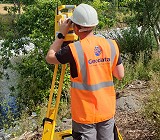
Precision Surveying Instruments
We utilise a range of high precision surveying instruments, including:
The Trimble DiNi digital level, capable of achieving 0.3 mm accuracy per kilometre when used with an Invar precision bar-code staff, ideal for detecting subtle vertical movements in structures and ground settlement.
The Trimble S9 high-precision total station, used for horizontal and vertical monitoring, providing millimetre-level accuracy for angular and distance measurements across large and complex monitoring networks.
Terrestrial laser scanners for comprehensive vertical deformation surveys and 3D comparison studies, allowing detailed analysis of walls, façades, and other structural elements over time.
By combining these technologies, we can accurately monitor both vertical settlement and lateral movement, offering clients a complete understanding of a structure’s behaviour.

Our monitoring services are suitable for a wide range of applications, including:
– Buildings and retaining walls
– Bridges, tunnels, and embankments
– Heritage and historic structures
– Deep excavations and basements
– Civil infrastructure and utilities
Site Control
We provide survey control and setting-out services at every stage of a project, from the initial control traverse to establishing and maintaining gridlines and datums used during construction and monitoring.
Geodata can establish survey control networks aligned to the Irish Transverse Mercator (ITM) Grid, National Grid, or local project grids, depending on specification and client requirements.
Accurate and consistent control is critical for all major civil engineering and construction projects. Our combination of precision instrumentation, robust methodology, and experienced field teams ensures dependable results that meet the highest industry standards
Deliverables
– Monitoring Reports
– Alert Thresholds & Notification Logs
.