At Geodata, our experienced surveyors specialise in capturing precise 3D data within the as-built environment using the latest 3D laser scanning technology.
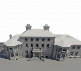
This data forms the foundation for accurate Building Information Modelling (BIM), giving architects, engineers, and project teams reliable information to plan, design and manage their projects with confidence

We are experts in the collection, processing, and management of point cloud data, ensuring every stage of the workflow from site capture to generation of final model is handled efficiently and to the highest standard.

Level of Detail (LOD)
Geodata BIM models are produced to recognised industry standards, including PAS 1192 and ISO 19650.
Models can be delivered to your specified Level of Detail (LOD) and Level of Information (LOI), typically ranging from LOD 200 to LOD 500, depending on project requirements.
– LOD 200 – Conceptual model suitable for early-stage design and spatial coordination.
– LOD 300 – Detailed model suitable for developed design and documentation.
– LOD 400 – Fabrication or construction-level model for on-site coordination.
– LOD 500 – As-built model reflecting verified site conditions.

This clarity ensures that every stakeholder knows exactly what level of accuracy, geometry, and data to expect, supporting efficient collaboration and dependable project delivery.
Deliverables
– Point Clouds (rcs, .e57, .las).
– BIM- Revit Models, DWG or IFC
– Topographical & Site Models
– Visualisations & Fly-throughs