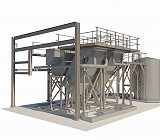
At Geodata, we use the latest Faro and Trimble TX8, X9 and X7 laser scanners, to capture highly detailed 3D point cloud data.
Each scanner is capable of recording up to one million points per second, while an integrated high-resolution camera captures panoramic colour imagery to produce rich, true-to-life colourised point clouds.

Our 3D laser scanning services are applied across a wide range of sectors, from pharmaceutical and industrial facilities to building and heritage projects, as well as road and rail infrastructure.

All point clouds are accurately registered and processed in Trimble RealWorks, ensuring exceptional precision and data integrity. From this, our in-house modelling team develops intelligent Revit models, providing clients with fully coordinated and BIM ready outputs.

Interactive 3D viewer
Our 3D web viewer outputs allow you to explore the scanned environment directly in your browser, view measurements, switch between panoramic images and point cloud data, and share information easily with your project team.

Whether you need raw point cloud data, an interactive 3D viewer, or a fully modelled Revit deliverable, GeoData provides precise, dependable information to support every stage of design, construction, and asset management.
Deliverables
– Point Clouds, .rcs, .e57, or .las formats
– 2D/3D CAD
– Revit Models, .rvt
– IFC Models for open BIM collaboration
– 3D Web Viewer Models