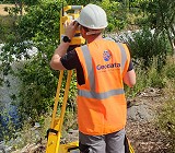
At Geodata, our Chartered Land Surveyors specialise in delivering high-quality, detailed Topographical Surveys to meet client requirements and RICS standards.
We combine traditional ground survey techniques, UAV (drone) mapping, LiDAR scanning, and 3D laser scanning technologies to provide precise, reliable data that supports planning applications, design development, civil engineering, and BIM modelling
Topographical Surveys
Our surveys accurately capture all visible physical features of a site, including:
– Ground levels and contours
– Boundaries, buildings, and surface features
– Roads, footpaths, kerbs, and retaining walls
– Vegetation, trees, and watercourses
– Drainage and utility covers
All surveys are tied national grid and Malin head datum, providing a clear and dependable base plan for architects, engineers, and planners.
Traditional Total Station & GNSS Surveys
Our experienced surveyors use high-precision total stations and GNSS receivers to record site data quickly and accurately. This method is ideal for urban or constrained sites where fine detail and millimetre-level accuracy are required

Drone (UAV) & LiDAR Surveys
Using our DJI Matrice M300 RTK platform equipped with LiDAR and high-resolution photogrammetry sensors, we can capture large or complex areas safely and efficiently.
This approach provides:
– Dense, georeferenced point clouds
– Digital Terrain Models (DTM)
– Orthomosaic imagery accurate to sub-centimetre levels
Ideal coverage for quarries, infrastructure corridors, and environmental monitoring, all drone operations are conducted by licensed pilots in accordance with IAA regulations.

Terrestrial Laser Scanning
For built environments and detailed structural surveys, we use high-definition terrestrial laser scanners capable of capturing millions of points per second. This allows us to:
– Capture existing buildings, façades, and complex geometry
– Produce as-built models, floor plans, and elevation drawings
– Integrate point clouds directly into CAD and BIM workflows

Mobile Mapping Surveys
Mobile Mapping is an advanced surveying technique that integrates GNSS, INS, LiDAR, and a range of other sensors mounted on a vehicle. This system enables the rapid collection of high-accuracy survey data while travelling at normal traffic speeds.
The method can be applied across a wide variety of environments, but it is particularly effective and cost-efficient for large scale road and rail infrastructure projects, where traditional static surveying would be time consuming or disruptive.
Mobile mapping delivers dense 3D point clouds and imagery, providing an accurate digital representation of the surveyed environment.

BIM Integration & Revit Surface Models
Our topographical data can be delivered as BIM ready Revit surface models, fully compatible with your preferred design software. Benefits include:
– Direct import into Revit and Civil 3D
– Coordination with architectural and engineering models
– Enhanced design accuracy and clash detection

Deliverables
Depending on project requirements, we can provide:
– 2D/3D CAD drawings (DWG/DXF)
– 3D point clouds (.RCP, .LAS, .E57)
– Revit surface models (.RVT)
– Orthophotos maps (GeoTIFF, PDF)
– Survey reports
.