All our Measured Building Surveys are conducted using High-definition laser scanning that enables rapid and precise data capture on-site, while UAVs are employed to survey roofs and other inaccessible areas efficiently
We specialise in delivering high-quality measured survey solutions tailored to a wide range of project types, Our expertise ensures precise and reliable survey deliverables.

TX8 High definition Laser Scanning
What is a Measured Building Survey?
A Measured Building Survey is a detailed digital representation of a site or structure, encompassing the precise mapping of both its internal and external components.
This survey provides an accurate record of the architectural and structural elements, capturing comprehensive measurements with meticulous precision.

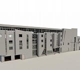
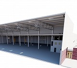
3D Model
Accurate Measurements
One of the key advantages of 3D laser scanning in the construction industry is its unparalleled surveying precision. These scanners capture dimensions with exceptional accuracy, generating detailed point cloud data.
This data can be converted into precise 3D models, providing a dependable basis for design, construction, and analysis.
The high accuracy of laser scanning minimises errors and enhances the overall quality of project deliverables.

High Definition Laser Scanning
Data Collection
High definition laser scanning enables rapid and precise capture of extensive on site data, while Drone UAVs are employed to survey roofs and other inaccessible areas efficiently significantly reducing time spent on site.
Reduces on-site risks by capturing data remotely, especially in hazardous or confined spaces.

Deliverables
Our comprehensive Measured Building Survey deliverables include:
– Point Cloud Data
– 2D/3D Drawings
– 3D BIM Models
– Photographic Records
– 360 degree viewer
Each deliverable is tailored to meet project-specific requirements with precision and detail..
 Click to view 3D Model
.